Urban planning, civil rights, and trends in landscape design in Savannah are highlighted in the newest collection available from the Digital Library of Georgia

5600PC-10, Minutes of the Park and Tree Commission, Volume 1, page 60 (page 72 of digitized item), November 9, 1896

In partnership with The City of Savannah Municipal Archives, the Digital Library of Georgia has just made the minutes of the Park and Tree Commission 1896-1929 available freely online.  

The historical significance of the collection may not be obvious at first, but Luciana Spracher, director for the City of Savannah Municipal Archives, describes its importance to contemporary research: 

“While on the surface the Park and Tree Commission Minutes might seem mundane, upon closer inspection they contain important information that reflects the intersections of urban planning and civil rights, trends in landscape design, development of Savannah’s cemeteries (both African American and white, since Savannah’s cemeteries were originally segregated), and details such as the use of convict labor in city infrastructure projects; all topics that draw on current socio-political trends and that are largely underrepresented in scholarship.”  

She adds:  

“Minutes from the early 20th-century discuss issues surrounding segregation of public facilities, such as public pools and park benches. These records offer insider perspectives into the decision-making process related to these Jim Crow-era policies that are not often found in governmental records.” 

Spracher also describes the importance of digitizing the collection for accessibility:  

“Currently this collection is underutilized by researchers because it is available only on site in our research facility in Savannah and is often overlooked as researchers are likely to believe it contains information limited to topics such as tree planting, parks and playgrounds. By digitizing the collection and sharing it through the Digital Library of Georgia (and thereby through the Digital Public Library of America), it will become more widely accessible to researchers in broad geographic locations.” 

Daves Rossell, professor of architectural history at the Savannah College of Art and Design 

adds:  “Having a doctorate in American architectural and urban history, with a specialty in vernacular architecture and cultural landscape, I have had call to use the Municipal Archives on many occasions, including in preparation for historic district nominations, historic landscape recordation, and a variety of research on individual buildings. Without the Park and Tree Commission’s records, such fundamental aspects of our civic heritage would be as good as lost. The Park and Tree Commission records are among the most diverse and valuable resources available on many such topics.” 

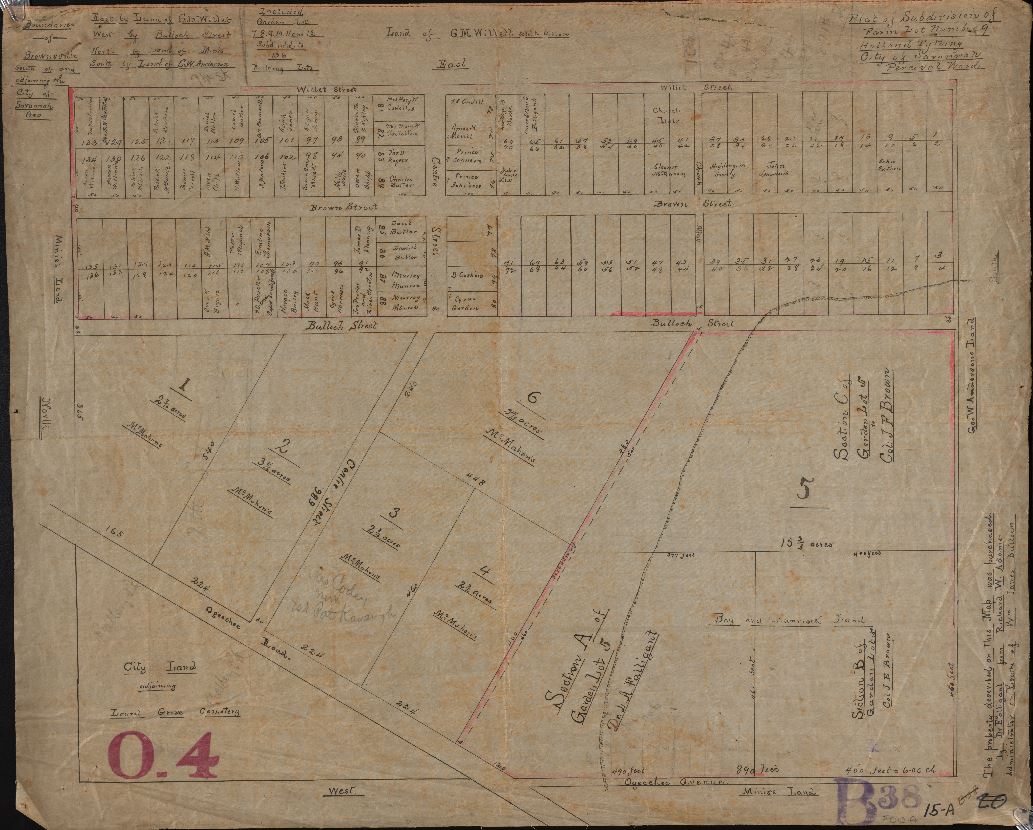
Link to featured images:  

Title: 5600PC-10, Minutes of the Park and Tree Commission, Volume 1, page 60 (page 72 of digitized item), November 9, 1896 

Description: 
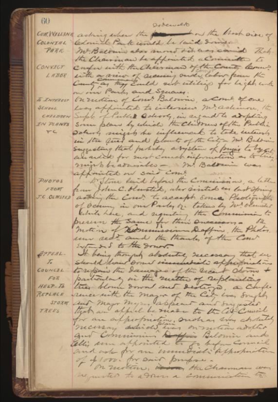
On November 9, 1896, the Park and Tree Commission minutes cover a range of topics including the sidewalk in Colonial Park Cemetery, the use of convict labor in parks and squares, working with Public Schools to interest children in plants, photographs taken by John C. Olmstead, and the replacement of trees after storm damage. 
Minutes of the Park and Tree Commission, Volume 1, page 60 (page 72 of digitized item), November 9, 1896
Title: 5600PC-10, Minutes of the Park and Tree Commission, Volume 2, page 370 (page 374 of digitized item) October 6, 1919 
Description:  On October 6, 1919, the Park and Tree Commission minutes cover topics including the prohibition of “negroes” from Laurel Grove North Cemetery and a requirement of a photograph for “negro servants” allowed to care for lots, as well as the use of Emmet Park or Franklin Square for a Naval Radio Station. 

About the City of Savannah Municipal Archives  

The City of Savannah Municipal Archives collects, manages, preserves, and makes accessible records documenting the City of Savannah’s history; administers the records management program and the City Records Center to increase the efficiency of City agencies; and shares the City’s history with City employees, citizens, and visitors through outreach activities. The Municipal Archives services reference requests from researchers and the general public which relate to archival and historical City records under its administration in the City Records Center, and shares the City’s history through a variety of public outreach activities, including tours of City Hall, permanent and rotating exhibits, and special programs. Discover the Archives at www.savannahga.gov/MunicipalArchives.   

About the Digital Library of Georgia 

Based at the University of Georgia Libraries, the Digital Library of Georgia is a GALILEO initiative that collaborates with Georgia’s libraries, archives, museums, and other institutions of education and culture to provide access to key information resources on Georgia history, culture, and life. This primary mission is accomplished through the ongoing development, maintenance, and preservation of digital collections and online digital library resources. DLG also serves as Georgia’s service hub for the Digital Public Library of America and as the home of the Georgia Newspaper Project, the state’s historic newspaper microfilming project.  

Visit the DLG at dlg.usg.edu

Facebook: http://facebook.com/DigitalLibraryofGeorgia/  

Twitter: @DigLibGA 

Share

Historical Savannah city maps available online

The Digital Library of Georgia is pleased to announce the availability of three new historical map collections from the City of Savannah Municipal Archives:

  •     Record Series 3121-007, Engineering Department – General Maps, 1798-1961, no date,

https://dlg.usg.edu/collection/gsg_edgm, which contains maps from 1798 to 1961 that illustrate Savannah property holdings, as well as land subdivision for City and private development. The maps also record property lines, right-of-ways, water and sewer lines, and street openings. Many maps include the names of property owners.

  •     Record Series 3121-019, Savannah Cadastral Survey – Ward Survey Maps, 1939-1940,

https://dlg.usg.edu/collection/gsg_scswsm. This collection includes survey maps of Savannah’s wards prepared in 1939 and 1940 by the Works Progress Administration (WPA) as part of the three-year, $65,000 WPA Savannah Cadastral Survey project. The city of Savannah is laid out in a system of wards, or blocks of land. The Cadastral Survey included all wards within the City’s corporate limits at the time. On May 9, 1940, Major H. U. Wallace, District WPA Engineer, presented Mayor Thomas Gamble with the Ward Survey Maps at City Hall. The survey was originally intended for use of the local tax assessors, but it has also proved useful for planning public utilities and improvements, determining property lines, and tracing the history of buildings and properties.

  •     Record Series 3121-020, Engineering Department – Major Subdivision Maps, 1871-1972, no date, https://dlg.usg.edu/collection/gsg_edmsm, which includes 249 maps of Savannah neighborhoods and subdivisions submitted to the City of Savannah Engineering Department for review and approval. The maps were prepared by a variety of surveyors and engineers, representing the City of Savannah, Chatham County, and private engineering and architectural firms. Many of the maps are copies or tracings submitted to the Engineering Department. Some of the maps include approval information by the City Engineer, County Engineer, Chatham-Savannah Metropolitan Planning Commission and/or the Mayor and Aldermen of the City of Savannah.

These historical maps are a rich resource documenting the development of Savannah’s town plan, wards, and neighborhoods through the 18th, 19th, and 20th centuries. Within the General Maps collection, the City of Savannah Municipal Archives has included a very early 1798 township map that documents the extension of the “Oglethorpe Plan” outside of the town limits to encompass the garden and farm lots. This, along with the progression of maps throughout the 19th and 20th centuries, show how Savannah’s unique plan was executed and evolved. The maps can be studied by urban planners, historians, and preservationists, and provide important insight for people making planning decisions today. The City of Savannah Municipal Archives has seen a dramatic increase in researcher interest in Savannah’s 20th century development, including citizens and community groups trying to document their neighborhoods, as well as historians researching the loss and preservation of Savannah’s infrastructure and built environment and how that fits in to a national context. The inclusion of the mid-20th century Ward Survey Maps provides a valuable point-in-time snapshot of Savannah before the preservation movement began.

Luciana Spracher, director of the City of Savannah Municipal Archives, notes: “The maps are regularly used by students (K-12 and college), historians, homeowners, citizens/residents, City staff, etc., and online access will surely increase this use and expand our geographical reach to those outside of Savannah who cannot physically come in to City Hall. We’ve also recently seen an increase in the ways in which people are using historical records, not just for traditional academic works, but for art applications and digital humanities projects. We hope that greater access to our records, and to a younger audience that may not access them through traditional onsite visits, will encourage new interactions with archives and new innovative projects.”

About the City of Savannah Municipal Archives

The City of Savannah Municipal Archives collects, manages, preserves, and makes accessible records documenting the City of Savannah’s history; administers the records management program and the City Records Center to increase the efficiency of City agencies; and shares the City’s history with City employees, citizens and visitors through outreach activities. The Municipal Archives services reference requests from researchers and the general public which relate to archival and historical City records under its administration in the City Records Center, and shares the City’s history through a variety of public outreach activities, including tours of City Hall, permanent and rotating exhibits, and special programs.

About the Digital Library of Georgia

Based at the University of Georgia Libraries, the Digital Library of Georgia https://dlg.usg.edu is a GALILEO initiative that collaborates with Georgia’s libraries, archives, museums, and other institutions of education and culture to provide access to key information resources on Georgia history, culture, and life. This primary mission is accomplished through the ongoing development, maintenance, and preservation of digital collections and online digital library resources.  DLG also serves as Georgia’s service hub for the Digital Public Library of America and as the home of the Georgia Newspaper Project, the state’s historic newspaper microfilming project.

Featured image:  Boundaries of Brownsville, south of and adjoining the City of Savannah Geo. [Bounded on the] east by land of G. M. Willis; west by Bulloch Street; north by land of Minis; south by land of G. W. Anderson. Included Garden Lots 7, 8, 9, 10, 11 and 12 subdivided to 136 building lots.

Record Series 3121-020, Engineering Department – Major Subdivision Maps, 1871-1972, no date

City of Savannah Municipal Archives

http://dlg.galileo.usg.edu/id:gsg_edmsm_edmsm-015-a

This project was made possible through DLG’s Subgranting Program

Share