The Digital Library of Georgia has just made Sanborn fire insurance maps produced between 1923-1941 for 39 Georgia towns and cities in 35 counties freely available online. The maps, which are now in the public domain, can be retrieved at dlg.usg.edu/collection/dlg_sanb, and complement the DLG’s existing collection of the University of Georgia Map and Government Information Library’s 539 Sanborn maps dating from 1884-1922 that have been available since 2005. The DLG has also upgraded its image viewer, which will allow better access and improved navigation to the new and older Sanborn images from this collection.
Sanborn maps were designed to assist fire insurance agents in determining fire hazards for properties by outlining the construction of buildings and their elements, as well as the location of water facilities, house and block numbers, and the names of streets. They have proven useful in researching urban growth and decline, urban planning design, and the historic use of buildings in a city.
Cari Goetcheus, associate professor in the College of Environment and Design at the University of Georgia notes: “Sanborn maps are a wonderful snapshot of place in time from the late 1800s to the mid-1900s.
Originally created by insurance companies to understand building materials in cities so they could decide what and how to insure the built environment, these maps offer much more than that by providing insight into Georgia’s diverse cultural, political, social, economic, and geographic history.
For example, my students and I have most recently been using Athens Sanborn maps to document land-use change in an area known as Hot Corner, the historically black business district of Athens from the late 1800s to the 1970s.”
Valerie Glenn, librarian and Head of the University of Georgia’s Map and Government Information Library notes:
“Because the maps contain such rich details, they provide a clear picture of a town as it existed –culturally, socially, economically, geographically. Users can see how many banks, or theatres, or piano stores existed; the “colored” schools and churches; and the distance between the river and the cigar factory.
Over time this makes it easier for users to, for example, identify changes to historically African-American neighborhoods in a given town or see the development, expansion, and/or decline of a central business district.”
Link to featured images:
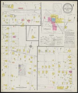
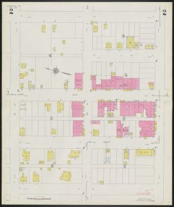
Arlington, Calhoun and Early Counties, Georgia, Apr. 1934/ Sanborn Map Company
Fire insurance maps which show building construction by hand coloring, locations of elevators and windows, and available water facilities. Shows commercial and religious occupancy of buildings, dwellings with property boundaries, and house and block numbers. Includes notes on population, water facilities, fire department, and prevailing winds. The maps represented are from the University of Georgia Libraries Map Collection.
Arlington, Calhoun and Early Counties, Georgia, Apr. 1934/ Sanborn Map Company, Page 1
Arlington, Calhoun and Early Counties, Georgia, Apr. 1934/ Sanborn Map Company, Page 2
Arlington, Calhoun and Early Counties, Georgia, Apr. 1934/ Sanborn Map Company, Page 3
About the University of Georgia Map and Government Information Library
The University of Georgia Map and Government Information Library (MAGIL)’s mission is to provide bibliographic, physical and intellectual access to cartographic and government information in all formats. The UGA Libraries serves as Georgia’s regional depository for documents published by the Federal government as well as the official depository for documents published by the State of Georgia. Its collections include select international and United Nations documents. Cartographic resources include maps, aerial photography and remote sensed imagery, atlases, digital spatial data, and reference materials, with a particular emphasis on the State of Georgia. Visit libs.uga.edu/magil
About the Digital Library of Georgia
Based at the University of Georgia Libraries, the Digital Library of Georgia is a GALILEO initiative that collaborates with Georgia’s libraries, archives, museums and other institutions of education and culture to provide access to key information resources on Georgia history, culture, and life. This primary mission is accomplished through the ongoing development, maintenance, and preservation of digital collections and online digital library resources. DLG also serves as Georgia’s service hub for the Digital Public Library of America and as the home of the Georgia Newspaper Project, the state’s historic newspaper microfilming project. Visit the DLG at dlg.usg.edu.